Summertime Temperatures Return for Cape
Forecast:

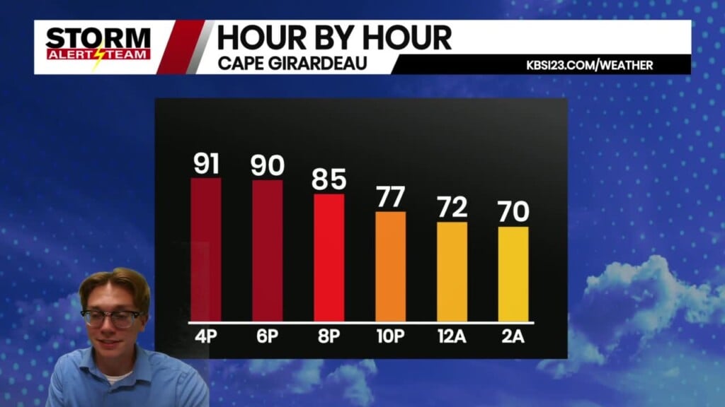
Mostly sunny skies once again on Thursday for much of the Heartland as we enter a warmer stretch going into the middle of September. High temperatures today will reach the lower 90s with a light wind out of the north.

There is a chance for isolated showers across our area this afternoon, which could bring a few sprinkles around 2-3 p.m. during the hours of peak daily heating.

Low temperatures this evening will fall into the mid-60s with mostly clear skies. A light wind out of the northeast will help try to cool us down overnight.

Mostly clear skies for the morning commute on Friday. Temperatures will be in the upper 60s and mid-70s for the drive to work or school on the last day of the work week.

Another sunny and hot day is ahead for Cape Girardeau on Friday to close out the week. High temperatures in Cape tomorrow will reach the lower 90s with a light and variable wind.

Highs across the region will be in the lower and middle 90s for Friday with plenty of sunshine. This puts us nearly 10 degrees above average for our high temperatures in mid-September.

Higher levels of humidity join the warmer temperatures with dew points near 70 degrees. This will have the chance to push the heat index up into the triple digits.

Temperatures continue to climb through the weekend, reaching a peak on Sunday and Monday afternoon. Highs continue in the mid-90s throuhg the middle of next week, with mostly sunny skies through the entirety of the forecast period.
Storm Alert Team Meteorologist
Dominic Ferraro


